

Space Optics Glossary
When we talk about instruments and optical systems, we very often use terms like GSD, FOV or Focal Length. To use them is one thing, but to understand them is another. In today’s article, we will lean into these terms by explaining what they specifically mean and how to interpret them.
GSD
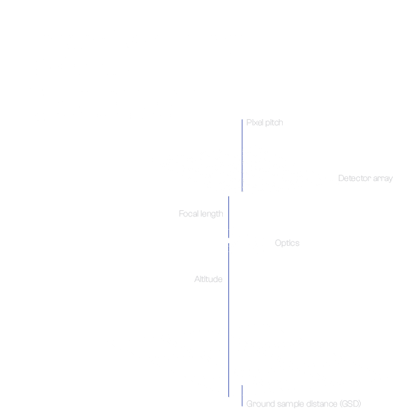
GSD is an abbreviation for ground sample distance. In photography, it refers to the distance between the centers of pixels next to each other. The smaller this value is, the better image we are able to obtain, the representation of reality in the image is better; smaller details are visible.
For example, if an optical system has a GSD of 1 meter (like our EagleEye telescope), it means that a single pixel in the image actually corresponds to an area of 1 x 1 meter.
FOV
FOV (Field of View) is a term that describes the area that can be seen by an optical system. It can be given either as an angle or a specific area (e.g. for our STAR telescope it is 102.4 x 76.8 km). The larger this value, the larger the area seen by the optical system at one time, and therefore more data can be acquired at one time.
SWATH
It is a term used in satellite imaging to define the area that can be scanned (photographed) in a single scan. It is a parameter defined by the field of view. The satellite system can photograph the Earth in two main modes: across or along the track. The latter has no moving parts thanks to the linear array of detectors; it also provides a better quality image.
Aperture
In optics, an aperture is an opening (a hole) through which light travels; it controls the amount of light that gets to a sensor. The larger the aperture (the lower the f-number on a lens), the more light gets into a camera, so the exposure times can be much faster.
The aperture, in conjunction with the focal length, determines the angle of the beam of light that can reach the sensor.
Focal length
Simply put, the longer the focal length, the higher the magnification of a lens. More scientifically, it is the measure of how quickly the optical system converges (or diverges) the light rays entering the system. Typically, the longer the focal length, the more light must enter the lens (thus requiring longer shutter speeds) to produce a photo as sharp as a shorter focal length. This is because you are collecting light from a smaller area (at a smaller angle).
For example, standard commercial lenses have a focal length of 18-55 mm, while telephoto lenses have a focal length of 100-400 mm. You can see much farther with more detail on a second one.
The STAR telescope has a focal length of only 106.6 mm, which provides a larger field of view, allowing more information to be collected in a single orbit.
Image resolution
In optics, it is the set of values that describes how many pixels make up a single image. For example, if a photo has a resolution of 300×200, it means that it consists of 300 pixels horizontally and 200 pixels vertically, for a total of 60,000 pixels in a single image.
However, pixel sizes vary. This is why the 24 MP (megapixel) photo from your smartphone looks completely different from the „same” 24 MP photo from your DSLR, which has a much larger sensor.
The higher the resolution, the more data is stored in an image. However, this comes at a cost – the photo requires more data, which in the satellite imagery industry means more precious bandwidth.
Focal ratio
Focal ratio is a measure of „lens speed.” This value can be obtained by dividing the focal length of the lens by its aperture. The smaller this value is, the less time or less light the lens needs to take a sharp picture. Smaller values also allow you to use smaller ISO values, which positively affects the quality of the resulting image.
Summary
As you can see, many parameters in optics are interrelated. If you change one of them, it often affects another. We hope that this article has explained some of the terms commonly used in optics.
Images source: Scanway, based on https://www.youtube.com/watch?v=BjPzNXGkJOY&ab_channel=NCSUGeoForAllLab and https://web.pdx.edu/~jduh/courses/Archive/geog481w07/Students/Goralski_SpatialResolution.pdf