

Let's talk about the fundamentals
The most common questions about satellites
In today’s article, we will answer some basic questions that may be on the minds of aspiring space enthusiasts.
Are satellites visible from Earth?
This depends on the time moment under consideration and the location of the satellite in orbit. Generally speaking, satellites are too small and move too fast – the first space velocity for Earth is 7.91 km/s.
Nevertheless, it is possible to observe a satellite with the naked eye in a few cases – take, for example, the incredibly recently popular Starlinks, whose „trains” can be seen immediately after their launch – which is due to the fact that they reflect solar light very effectively from their structure. Being criticized by the astronomical community (obstruction, distortion of research results) SpaceX changed the design of the satellites using a low-reflectivity coating, which slightly but not sufficiently reduced the problem. Once the orbit is raised, Starlinks’ visibility decreases.
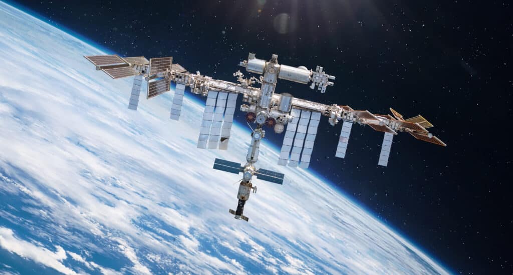
Another example of a highly visible satellite is the International Space Station (ISS), whose overflights are regularly visible in various parts of the world – sometimes there is even media coverage of them. The reason for its visibility is the very large surface area of both the entire station, but more so the solar panels, which reflect a lot of the sun’s rays.
Why satellites don’t fail?
Satellites do not fail, usually – but why? How are they different from ordinary home electronics?
Let’s start with the design itself – each part or system goes through multiple reviews, the components are designed according to standards (e.g. ECSS), which ensure that engineers have anticipated all factors and challenges and designed the satellite taking them into account.
Before being launched into space, satellites undergo incredibly complex and numerous tests – there are even separate types of satellite models for testing! Laboratory models, for thermal testing, structural testing, engineering models, qualification models, simulators, and finally flight and backup models
Each model undergoes its respective tests and meets its purpose in the process of building, pre-flight troubleshooting, and then even testing the more risky maneuvers. Only by successfully passing all the required tests can the satellite be launched.
Why do satellites stay in orbit?
The satellite remains in orbit due to the equilibrium of centripetal force and gravitational force. In an ideal world, a satellite once placed in orbit will remain in orbit indefinitely – which has its pros and cons. The plus is that there is no need to use propellants to raise the orbit. The downside is that the satellite, once damaged – or even after naturally fulfilling its mission (aging components, degrading solar panels), will remain in its orbit indefinitely, taking up valuable space, being de facto 'space junk’ and increasing the risk of collisions with other objects.
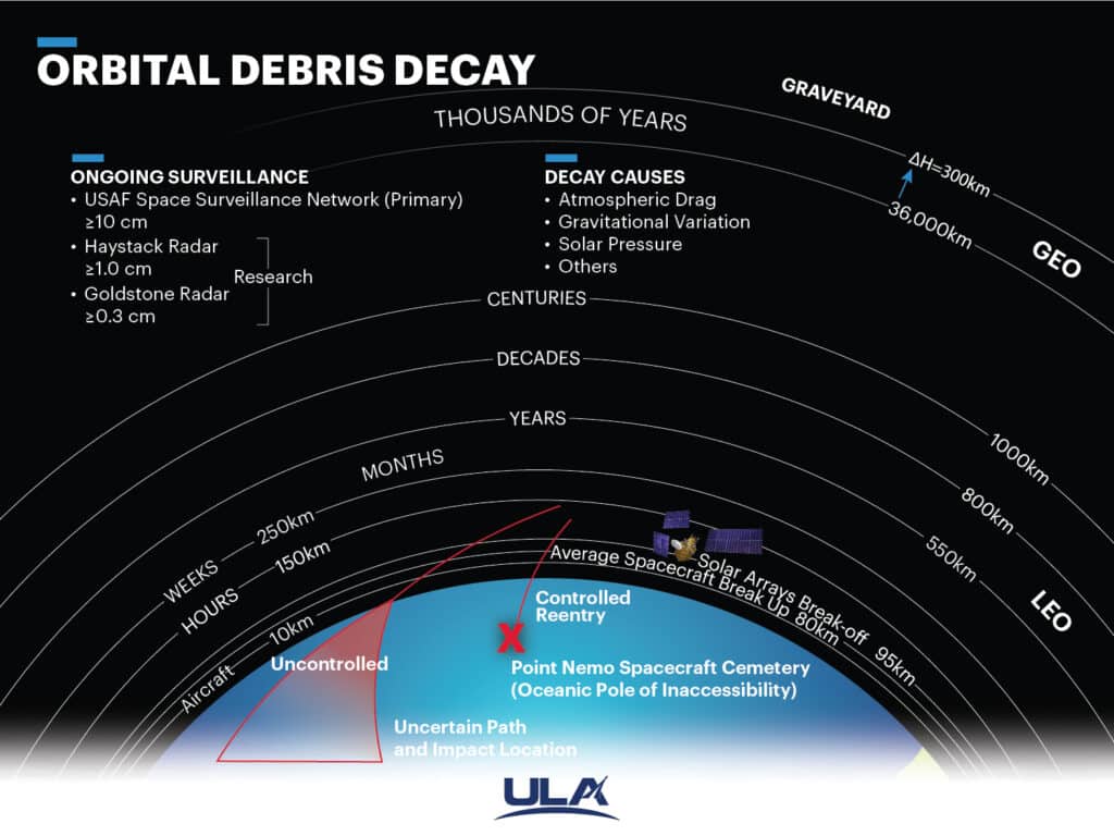
In the real world, hardly any satellites move in a perfectly circular orbit, and with time, there is a decrease in the height of the orbit due to various perturbations – such as perturbations from aerodynamic drag, solar radiation, the interaction of third bodies, the Earth’s magnetic field, or the non-uniformity of the Earth’s gravitational field. These perturbations affect objects differently depending on the altitude, inclination, surface, reflectivity, or mass of the satellite under consideration; nevertheless, in low orbits aerodynamic drag has the greatest impact on the body. The following graphic shows the average lifetime per satellite in a given orbit if there is no orbit raising.
What exactly can satellites see?
Have you ever wondered how accurate satellites are? What is the practical limit of resolution? In satellite technologies, when discussing what is observable, a unit of „meters per pixel” is used. Different observation satellites, depending on the technology used, the height of the orbit, or their size, are able to achieve different resolutions. What’s more, different imaging objectives require different resolutions – if the goal of the mission is to capture larger trends, such as imaging the entire planet for research purposes (assessing climate change, land use, and thermal observations), then lower accuracy is sufficient. For example, this is the task of Landsat satellites operated by NASA and UGSS, of which the latest has a spatial resolution of 15 m, 30 m and 100 m (depending on a spectral band). If the goal is very accurate imaging of single locations, then higher resolution is required – for example, this is accomplished by Maxar satellites, whose best spatial resolution is 31 cm.
For example, the Scanway STAR telescope imaging our planet’s surface from the beginning of 2023 has a spatial resolution of 25 meters per pixel. This means that each pixel in the image taken corresponds to 25 meters in reality. Another Scanway telescope being designed for the EagleEye satellite is expected to have a resolution of 1 meter per pixel.
How are satellites launched?
Generally speaking, the journey of any satellite begins with a rocket that will carry the device into space. But how this happens is another matter – let’s put the knowledge in order:
The first case, used for satellites launched into very demanding orbits, or those that are very heavy – and especially a combination of both facts – are launched on a dedicated launch, where they are the only payload – an example of such a mission is the recent Falcon Heavy rocket launch, which carried the Jupiter-3 satellite into a GTO orbit (you can read more about the types of orbits here), which weighed a whopping 9200 kg. Smaller rockets (Rocket Lab’s Electron, the European Space Agency’s Vega) or „space startups'” rockets, due to their smaller size types, are able to launch smaller satellites into dedicated orbits at more „reasonable” prices, which makes it possible not to have to compromise between price and the best orbit (as often during shared launches) – with an individual launch, the orbit height and inclination depends only (in addition to the wealth of your wallet) on the rocket’s capabilities and arrangements with the launching company.
If the satellite is smaller, it is possible to save funds by using a split launch, which is able to put multiple satellites into a common (sometimes several are possible) orbit – this is usually used for objects that have similar applications – for example, imaging constellations can be launched into sunsynchronous orbit during joint launches. This type of launch was used by Scanway’s STAR VIBE satellite, which was sent into an orbit with an altitude of more than 500 km during the Transporter 6 mission in early 2023.
A third type of satellite launch that is rarely discussed is the journey to the International Space Station (ISS) in capsules carrying supplies. The satellite is placed in a special tray by astronauts using robotic arms, or released „out of hand” during a spacewalk.
Satellite constellations – what is it?
It’s always better off in a group – satellites included. By definition, a constellation is a group of satellites in one (or many similar) orbits working together to achieve a common goal. The constellation that everyone uses on a daily basis is that of the GNSS system, better known as GPS. This system contains 32 active (and 6 spare) satellites in orbit at an altitude of 20180 km; there are also its foreign alternatives, rather unused by Western countries – China’s BeiDou and Russia’s Glonass. Each satellite of these systems operates separately, however, to correctly locate a position using GPS it is necessary to be visible by a minimum of four satellites simultaneously, with each additional satellite reducing the dilution of precision (DOP).
Another type of constellation is a formation. These are also a minimum of two objects, however, only the cooperation of the objects with each other enables them to fulfill their purpose. An example of such a system is the satellites from the Intruder program, which are able to track a signal using triangulation.
How do satellites work?
The answer to this question is both simple, but also very complicated – this question can be answered on many levels. Let’s assume that our considerations concern an object that is not passive – its task is more than its mere presence in space.
A satellite has several basic subsystems:
- Propulsion module – this is not a mandatory module, usually absent in small vehicles. Nevertheless, its presence is very helpful and makes it possible to change position in orbit or raise it regularly.
- Communication module – allows data exchange with engineers.
- Data storage module – the satellite is not always near a ground station, so data collected during the rest of the orbit must be stored until it can be sent.
- Heat exchange system – there is no air in space, so heat exchange through convection is not possible. The big problem is both overheating of the vehicle components, but also being too cold to operate.
- Structure – all other systems are fixed in the structure. It can be said that it is the frame on which everything rests.
- AOCS – Attitude Orbit Control System – a system that allows you to change the orientation of the satellite in orbit, such as with reaction engines.
- Power system – different equipment requires different voltages or frequencies of electricity. The power system is also responsible for distributing power wherever it is needed. This system also includes solar panels.
- Payload – e.g., telescopes, scientific experiments. Anything that is not directly required for just being in orbit. All of these systems are interdependent, the satellite would not be able to fully function even after the failure of just one.
How satellites communicate with engineers?
In order for it to be possible for an engineer to contact a satellite, it is necessary to have antennas both on the space vehicle, but also on Earth. Transmission from the ground segment is carried out from places called ground stations. These contain both transmitting and receiving antennas, as well as entire systems that enable data transmission. It is obvious that engineers do not want third parties to have access to the collected data, so the signal is often encrypted. Ground stations can often be operated remotely and shared by multiple companies, so it is not necessary for each operator to have its own private station at site.
Do you have more questions about satellites or space payloads? Let us know via [email protected], we’ll be happy to answer them!